Driving Instructions
Colorado Campus
TRAIN ON OVER 3000 ACRES OF PRIVATE LAND IN THE BEAUTIFUL MOUNTAINS OF COLORADO
WELCOME TO THE SURVIVAL UNIVERSITY CAMPUS
Watch our video to enjoy scenes from the TSU campus. We are excited to welcome you to the mountains for an immersion into the wild.

Driving Directions to the Colorado Survival School
*All Colorado Survival Classes are located outside of Cripple Creek, CO which is about 50 minutes West of Colorado Springs.
For Google Coordinates click below–do not rely on Google Maps or GPS for exact Directions. Please read the directions listed below.*
Using Your Smart Phone
Enter COLORADO MOUNTAIN MAN SURVIVAL or THE SURVIVAL UNIVERSITY for general driving directions. However, we still suggest you read the directions lower down on this page before driving to our location.*
WARNING
Please do not show up to our school location without a reservation as it is behind a locked gate. You will have to pass through a private mining operation which is under constant video surveillance and patrolled by private security.
If the gate is closed, please contact us at 719-684-4147.
Gray Route
THE RECOMMENDED ROUTE
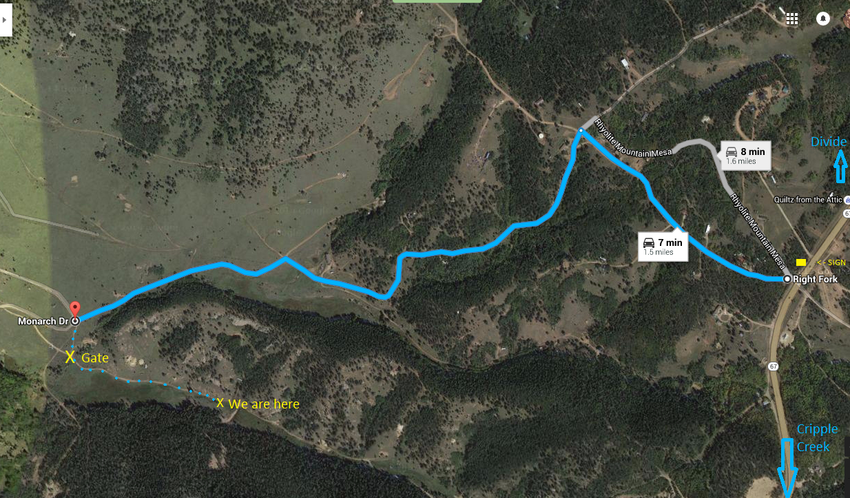
While Google Maps will send you in another direction (see Blue Route below), we recommend taking this alternative route, as the road is typically in better condition. The road marked in Gray on this map is County Road 1 (CR1) or Teller 1.
- HWY 24 - West from Divide to Florissant (8.2 miles)
- CR1 - South from Florissant (13.6 miles)
- Left on Anges Dr (at the church)
- Right on Troy
- Left on Copper Mountain
- Left on Monarch
Drive about 1 mile, then take a right at the Y intersection leading to our double green gate. If you spot a house that looks like it belongs in a Dr. Seuss book on the left side of the road as the terrain becomes notably rocky while ascending a hill, you've overshot the Y intersection and gone a bit too far. If you make it to the Dr. Suess house, back up and look downhill for our gate.
.png)
Blue Route
THE NOT RECOMMENDED ROUTE
The Blue Route is the route Google Maps will suggest from Colorado Springs. It is the fastest route but may not be suitable for all vehicles or drivers. The Gray Route is slightly longer, but the road is in better condition. Both routes are passable with any vehicle depending on your comfort level with driving your vehicle over rough terrain.
- From Colorado Springs, head West 26 Miles on US-24 to Divide, CO
- Turn Left (South) onto CO-67 (towards Cripple Creek)
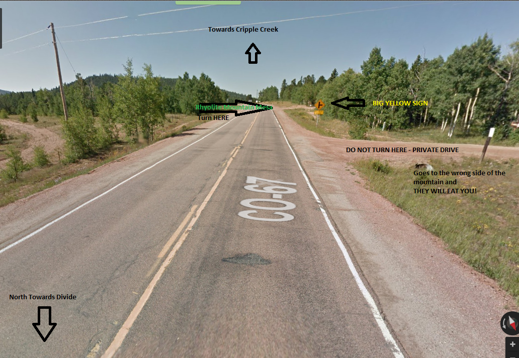
- Drive 15 Miles and turn RIGHT on Rhyolite Mountain Mesa
(There is a yellow sign for this road on Hwy 67–turn past the sign. See picture at the bottom of this page.)
*Please note that Google Maps calls this road Right Fork. It is Rhyolite Mountain Mesa, not Right Fork.
FROM HERE FOLLOW THE SIGNS WITH THE WHITE ARROW IN THE BLACK DIAMOND

.png)
Drive .5 miles, and turn Left (South) at the next intersection, heading down the hill. Look for the BLACK DIAMOND signs along the way and follow the signs. Most people miss the sign at this intersection, often because they are looking at the house with all of the junk cars around it. Just past this house look for the sign and go left as noted.
Continue on 1.1 miles to Monarch Drive (Not marked. Look for other BLACK DIAMOND signs along the way.) You will go down a very rocky section of the road with a tiny home on the right that looks like it belongs in a Dr. Seuss book. Keep going about 200 feet to the next intersection. To the left you will see a double green gate with a survival school banner on it.
If you reach Copper Mountain Drive, you have gone too far.
Proceed through the gate. Park in the large dirt lot near the building made of shipping containers.
YOU HAVE ARRIVED!
2
DIRT ROAD AFTER TURNOFF FROM HWY 67

3
FIRST INTERSECTION THAT IS COMMONLY MISSED
.jpg)


