Cart
Sub-Total: $0.00
13 min read

Hey there, fellow adventurers! If you’ve ever found yourself staring at a map, wondering which way is up, or spinning a compass like it’s a fidget toy, you’re not alone. Navigation can feel like a mysterious art, but it’s one of the most rewarding skills you can learn. Whether you’re hiking through the wilderness, competing in an orienteering race, or just trying to impress your friends with your newfound sense of direction, understanding navigation opens up a world of possibilities. Today, I’m diving deep into the world of navigation, not because I’m an expert (yet!), but because I’ve got an incredible instructor, Matt Boger, a retired Army Ranger, coming to teach it at my survival school, The Survival University. I figured, why not share what I’m learning with you? This isn’t a sales pitch, but if you’re intrigued by the end, I’ll sprinkle in a few chances to join us for a class. Let’s get started!
First things first, navigation is the official term for finding your way from point A to point B, usually when roads and GPS aren’t an option. It’s the science and skill of plotting a course, reading the land, and using tools like maps and compasses to stay on track. Some folks confuse it with orienteering, and I get why. Orienteering is the sport of navigation, a fast-paced race where you dash through forests or hills, map in hand, hunting for checkpoints. It’s navigation with a competitive twist, and it’s wildly popular. But navigation itself? That’s the foundation, the raw skill that works whether you’re racing, exploring, or surviving.
I used to think navigation was just for old-school explorers or military types, but it’s so much more. It’s practical, it’s fun, and it gives you a sense of freedom. Imagine being deep in the woods, no cell signal, and still knowing exactly where you are. That’s the magic of navigation. Plus, practicing it is a blast. You don’t need a fancy course to start; grab a map, a compass, and a buddy, and you’re off on a mini-adventure. Trust me, there’s nothing like the thrill of nailing your location after a good trek.
You might be thinking, “Why bother with maps and compasses when my phone has GPS?” Fair question! But here’s the thing: technology fails. Batteries die, signals drop, and screens crack. Navigation is your backup plan, your superpower when the digital world lets you down. It’s also a lifesaver in emergencies. If you’re lost in the backcountry, knowing how to read a map and shoot an azimuth could get you home safe.
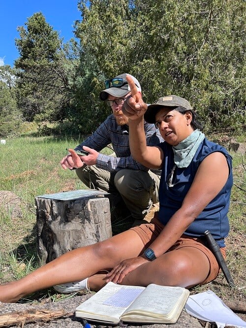
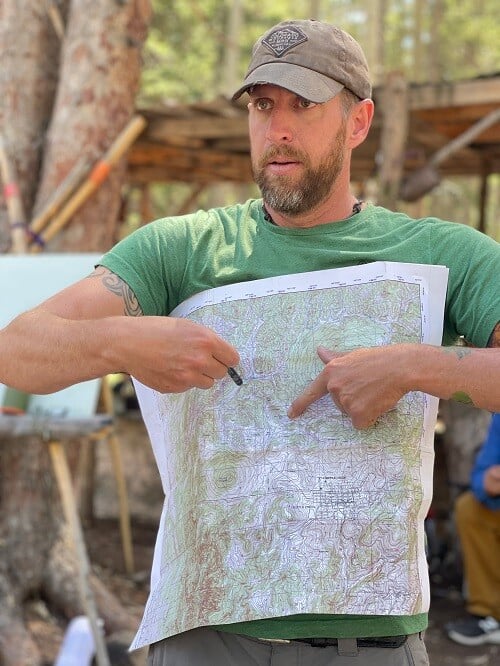
Beyond survival, navigation is just plain useful. Hikers use it to explore off-trail, hunters track game in remote areas, and orienteering enthusiasts turn it into a game. At The Survival University, we’ve even had the military send folks to train with us because our instructor, Matt Boger, is that good. He taught navigation to Rangers at Ranger School, and his skills are the real deal. Whether you’re a beginner or a seasoned pro, there’s something empowering about mastering this craft.
Navigation isn’t about guesswork; it’s about tools and know-how. Let’s break down the essentials and sprinkle in some technical goodies to get you excited.
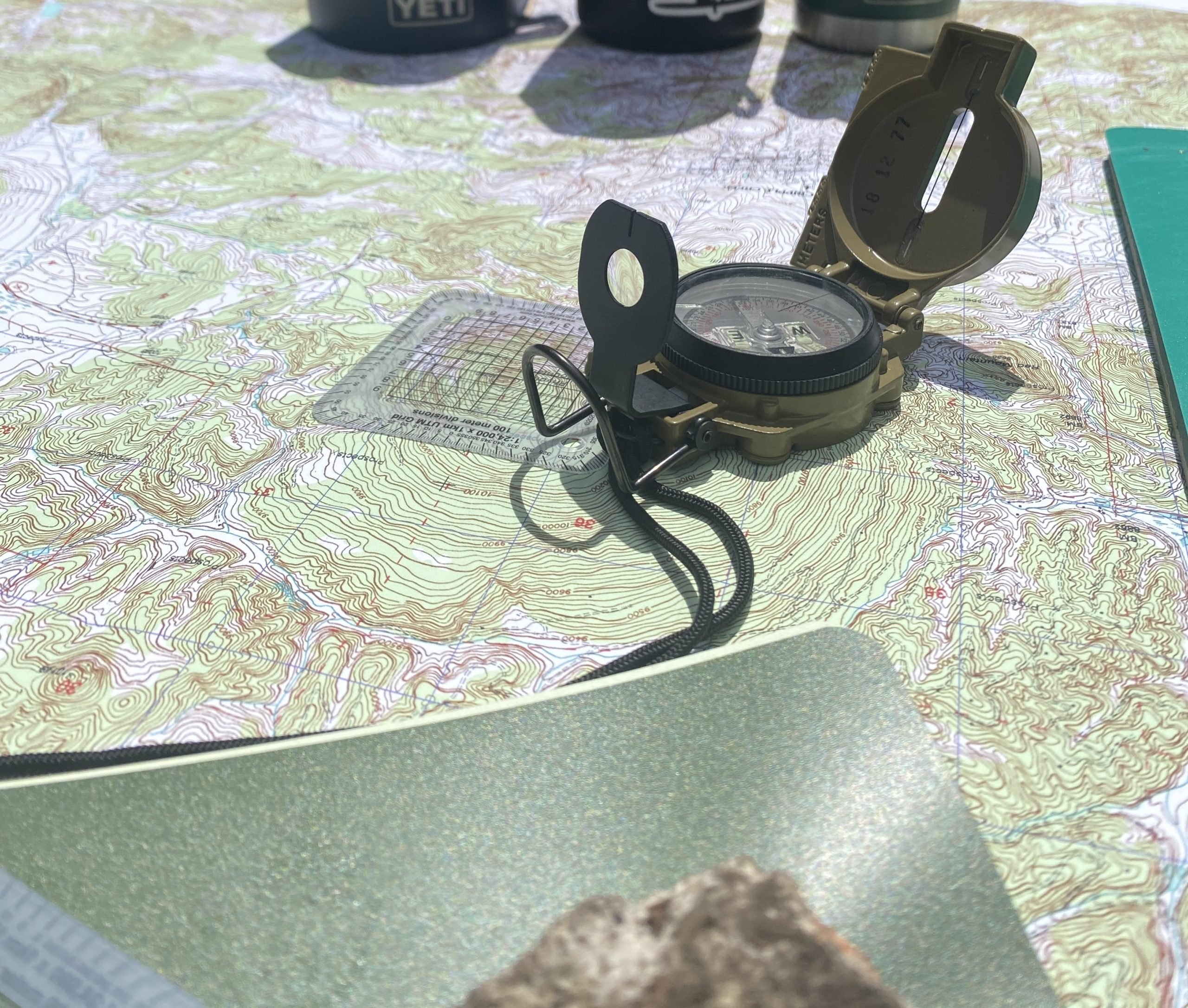
If you’ve never seen a topographical map (or “topo map”), you’re in for a treat. These aren’t your flat road maps; they’re detailed blueprints of the land, showing hills, valleys, rivers, and more. The secret sauce? Contour lines. These squiggly lines connect points of equal elevation, letting you “see” the terrain in three dimensions. Close-together lines mean steep slopes; spread-out lines mean gentle hills. It’s like having X-ray vision for the landscape.
Topo maps also come with grids, like the Universal Transverse Mercator (UTM) system. UTM breaks the world into numbered squares, making it easy to pinpoint your spot with coordinates. Think of it as a treasure map grid, but for real life. You’ll also find a legend explaining symbols (roads, streams, cliffs) and a scale to measure distance. It’s a lot to take in, but once you get the hang of it, you’ll feel like a cartographic wizard.
Now, let’s talk compasses. This little gadget is your north-star finder, and it’s more than just a needle pointing north. A good orienteering compass (the kind we use in our classes) has a few key parts:
Some compasses, like the lensatic ones Matt favors, have sighting features for precision. They’re rugged, military-grade, and perfect for serious navigation. Whether you’re a beginner or an orienteering racer, a compass is your ticket to staying on course.
Here’s where it gets fun (and a little geeky). An azimuth is the direction you’re heading, measured in degrees from north. North is 0°, east is 90°, south is 180°, and west is 270°. You “shoot” an azimuth by aiming your compass at a landmark and reading the degree mark where the needle lands. It’s like aiming a laser pointer, but with a needle.
Then there’s declination, the trickster of navigation. Magnetic north (where your compass points) isn’t the same as true north (the top of your map). The difference, in degrees, is declination, and it varies by location. In some places, it’s a few degrees; in others, it’s 20° or more. You adjust for it by tweaking your compass or doing some quick math. Ignore it, and you could end up miles off course. It’s a small detail with a big impact, and figuring it out feels like cracking a secret code.
So, how do you actually use this stuff? Picture this: you’re in the woods with a topo map and compass. You want to hike to a hidden lake three miles away. Here’s the play-by-play:
It’s a dance of map, compass, and terrain, and when it clicks, you’ll feel like a navigation ninja. Practice this in your backyard or a park, and you’ll be amazed at how fun it is to “find” your way.
Let’s zoom in on orienteering for a sec, because it’s a fantastic way to practice navigation. In an orienteering race, you get a detailed topo map with control points marked. Your job? Run (or walk) to each one in order, punching a card or tagging an electronic marker to prove you were there. It’s a treasure hunt on steroids, blending physical challenge with mental sharpness.
Orienteering maps are next-level, with 5-meter contour intervals and symbols for everything from boulders to thickets. They’re often aligned to magnetic north, which simplifies navigation by matching your compass needle’s natural direction, reducing the need to adjust for declination during a fast-paced race. Races range from beginner-friendly sprints to multi-day epics, and they’re a blast for all ages. If you’re into orienteering, navigation skills give you an edge; if you’re new, it’s a great way to learn.
Practicing navigation is like playing a real-life puzzle game. Every hill you climb, every stream you cross, becomes a clue. There’s a rush when you spot a ridge on your map and realize, “Hey, that’s right in front of me!” It’s you versus the wild, and winning feels awesome. Plus, it’s a skill you can flex anywhere: local parks, national forests, even your neighborhood (try plotting a course to the coffee shop!).
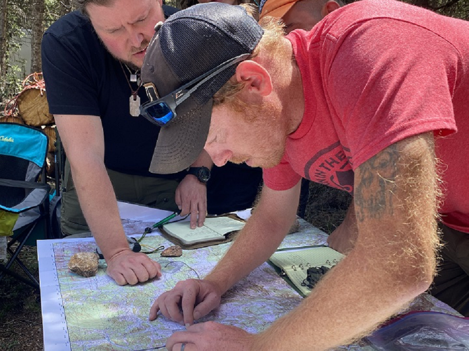
At The Survival University, we dive straight into the real stuff. Our Navigation – 3 Day Class with Matt Boger isn’t some watered-down beginner course or REI parking-lot nonsense—it’s a serious, hands-on navigation experience for all levels, from greenhorns to soldiers prepping for Ranger School. Matt, a retired Army Ranger, hammers home topo maps, compasses, and terrain association over three intense days, with hardcore field practice across our 1100-acre property. This is legit training, no fluff, built for anyone ready to step up. Curious? Hit our website for the details and see if you’ve got what it takes.
Ready for more? Let’s geek out on some advanced navigation tricks that’ll make you sound like a pro.
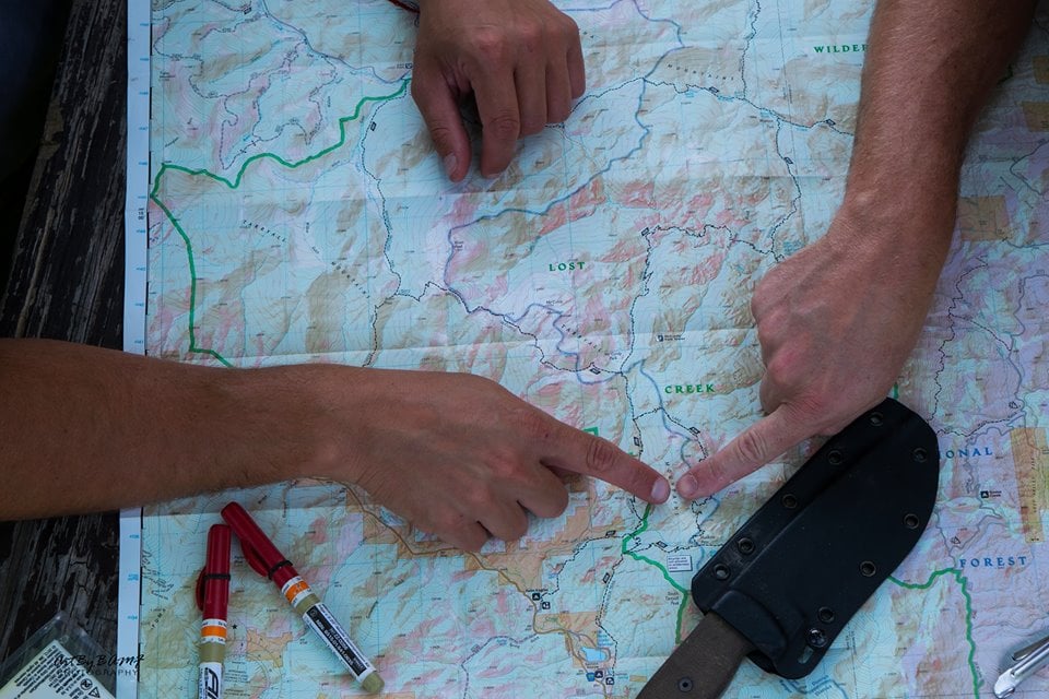
Contour lines are your best friends for “reading” the land. A steep drop? Tight lines. A flat meadow? Wide gaps. Pair this with terrain association—matching what you see (a peak, a saddle) to your map—and you’ll navigate without even glancing at your compass sometimes. It’s like the land whispers its secrets to you.
The UTM system is a grid lover’s dream. Each square has a number (easting) and letter (northing), plus smaller coordinates inside. With a ruler or protractor, you can nail your location within 10 meters. It’s technical, sure, but once you master it, you’ll feel unstoppable.
Here’s a cool one: pace counting. Count your steps (every two) over a known distance of 100 meters. In the field, use that to estimate how far you’ve gone. Pair it with an azimuth, and you’re golden. It’s low-tech, but Rangers like Matt swear by it.
Adjusting for declination is a rite of passage. Some compasses let you set it manually; others require you to add or subtract degrees. West declination? Add it to your azimuth. East? Subtract. It’s a brain teaser at first, but it’s second nature with practice.
One thing I love about navigation is how universal it is. Beginners can start with a park stroll, learning to orient a map. Orienteering racers can sharpen their speed and precision. And pros? They tackle rugged backcountry with confidence. At The Survival University, our Advanced Navigation – 3 Day Class with Matt Boger is an add-on course that’s no joke—one of the only ones with a prerequisite. You must complete our Navigation – 3 Day Class first, and we strongly recommend taking our 3 Day Survival Course and Wilderness First Aid Course before stepping up to this beast. Run on our 4500-acre ranch in brutal, rugged terrain, you’ll navigate tough landscapes, plan routes over obstacles, and camp out overnight. It’s intense, practical, and builds on the basics. The military always sends their people to both classes, but it’s open to any civilian with the grit to take it on. Check the description online if you’re up for the challenge!
Navigation isn’t just theory; it shines in action. Matt’s got tales from Ranger School about recruits finding their way through rugged terrain by azimuth and pace. I’ve heard from students who used our classes to win orienteering races or track elk in the Rockies. One guy even said it saved his bacon when his GPS died mid-hike. That’s the payoff: confidence, competence, and a good story to tell.
Ready to dip your toes in? Grab a topo map of your area, a basic compass (Suunto or Cammenga are solid picks), and start small. Orient your map at home, then try a short walk, matching landmarks as you go. Join an orienteering club for a fun twist, or just wander with a friend. Mistakes are part of the fun; every wrong turn teaches you something.
If you want a deeper dive, our classes at The Survival University are here for you. Matt Boger’s Navigation – 3 Day Class is your launchpad, hosted on 1100 acres of wild terrain at Location 1, our Main Camp (or Mountain Camp). The Advanced version pushes your limits even further, taking place on over 4500 acres at Location 2, known as Chapman Ranch. With a retired Ranger instructor leading the charge, these courses are all about real learning—no fluff, no parking-lot nonsense. It’s the real deal, built for everyone from newbies to orienteering champs, across two rugged, sprawling properties.
Navigation is more than a skill; it’s a mindset. It’s about curiosity, problem-solving, and trusting yourself. Whether you’re chasing orienteering glory, exploring the wild, or just wanting to know where you stand, it’s a journey worth taking. I’m stoked to learn from Matt and share this with you. So, grab a map, spin that compass, and let’s get lost—on purpose—together. Who knows? Maybe I’ll see you out there, plotting a course with a grin.
About the Author
Jason Marsteiner is the founder and lead instructor at The Survival University, where he’s turned his obsession with staying alive into a mission to teach real-world survival skills. Forget fancy gear—Jason’s all about the know-how that gets you through the wild or a city crisis. A published author of Wilderness Survival Guide: Practical Skills for the Outdoor Adventurer, he’s distilled years of hard-earned wisdom into lessons anyone can use.
Raised in Colorado’s rugged mountains, Jason’s survival chops were forged in the wild—from Missouri forests to Arizona deserts to Costa Rican jungles. He’s navigated it all with next to nothing, earning creds like Wilderness First Responder (WFR) and SAR tracking along the way. He’s trained thousands to keep cool when 911’s out of reach, proving survival’s not just for grizzled adventurers—it’s for hikers, parents, and city slickers alike.
Jason’s mantra? Everyone should make it home safe. When he’s not running courses, he’s designing knives, mentoring newbies, or chilling in the city like the rest of us—always sharpening the skills that turn panic into power.
Master navigation with maps and compasses. Explore orienteering, topo skills, and wilderness know-how in this ultimate guide.

Master real navigation skills beyond orienteering and geocaching. Learn to read terrain, use a map and compass, and navigate with confidence in any environment.